Camp Muir Mt. Rainer Day Hike Trip Report
Published: 09/14/2017
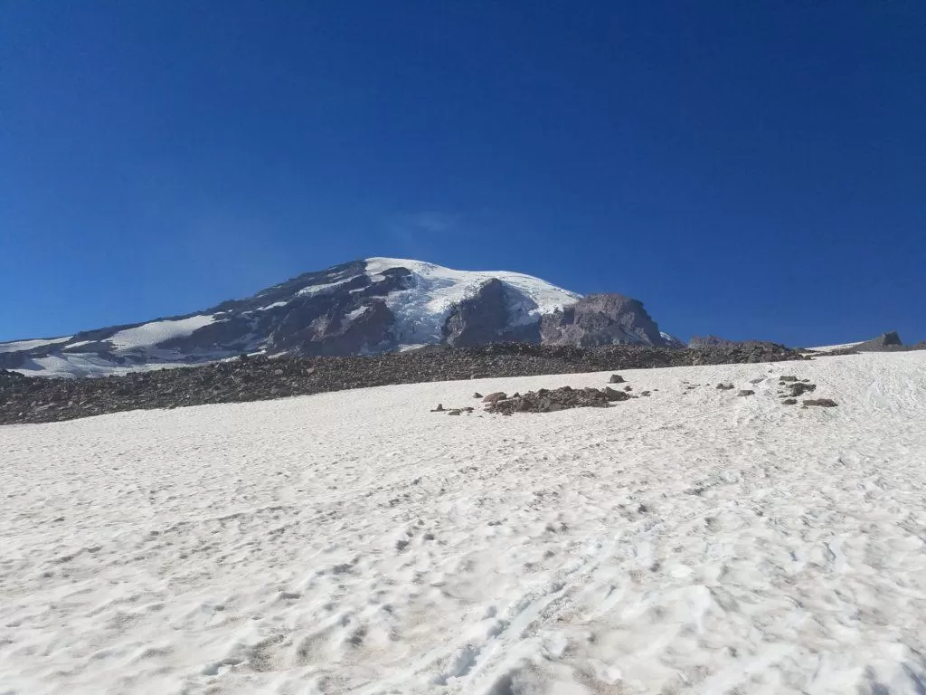
The Paradise to Camp Muir Route with Mt. Rainer in the Background
Hi! I am Maria Faires, RD. I am a mountaineering fitness and nutrition expert. I have worked with hundreds of mountaineers and hikers all over the world and am the preferred trainer for many premier international mountain guide companies.
I have hiked up to Camp Muir dozens of times and have perfected how I do it so I'd like to share a few tips and give you an idea of what the hike to Camp Muir is like.
This hike is a strenuous, yet rewarding, scenic ascent from the Mt. Rainier Paradise Visitor Center to the Camp Muir base camp for many Mount Rainier summit expeditions climbing The Ingraham Glacier/Disappointment Cleaver. Climbers usually hike to Camp Muir the day before they climb to rest and acclimate to the altitude, a little over 10,000 feet. I've done this hike countless times and this was my friend's first. We have been hiking all summer and he was fit and ready!
The trek to Camp Muir is exhilarating but is not a hike to be taken lightly. It's tougher than it looks and the weather can change unexpectedly. This hike is only recommended for strong, experienced hikers, who are prepared.
To make your trip safe and enjoyable use this Camp Muir Packing List. This is the list I have perfected over the years, I personally use and give to my clients.
I have some valuable tips for your Camp Muir Day Hike here.
We arrived at Paradise at 830am. Temps were in the low 60's. I elected to wear shorts, a wicking t-shirt followed by a wicking long sleeve, a down vest and a fleece jacket. After 10 minutes, I took off the vest and jacket.

We got our early start and were on the trail by 9 a.m. About 5 minutes into our hike, some hikers stopped to alert us that a bear was right off the trail. We easily saw the large black bear stripping berries off low bushes. He gave no indication that we even were there. We observed and photographed him then moved as a group past him.
The hike to Camp Muir starts on the Skyline Trail at Paradise, the nine-mile round-trip rambles innocently through gorgeous meadows, scrambling chipmunks and lolling fat marmots before climbing the strenuous (always) snow covered steep 2.2 miles and 2,800 vertical feet up the Muir Snowfield. This Skyline alpine trail contrasts to the world of rocky outcropping and the snow and ice of the higher mountain. We lucked out and despite starting the hike out chilly and in the low clouds with no view of Mt. Rainier, the clouds disappeared as we gained elevation and the sky was blue and the mountain, beckoning.
Conditions for hiking in snow were perfect and there was a good track to follow and we found that we did not need traction devices called microspikes though we carried them.
We kept a steady pace with a few rests on one of the rock slands in the snowfield. While snacking, we took in the views of the mountain ahead and the Tatoosh range behind which were breathtaking.
It took us 4.5 hours until we could see Camp Muir in the distance. Those last thousand feet of the climb are the most difficult. The Muir Snowfield seems to stretch on forever before you see the buildings and when you do finally see Camp Muir, it looks closer than it is and feels like you're making no progress at all as you climb. At this point we began the rest-step and pressure breathe to help to raise blood oxygen levels.
Once we got to Camp Muir, after 5 hours of steep hiking, we found it relatively quiet. There was a group of RMI climbers RMI just led up as we were climbing, a few day-hikers and a few men who were attempting the summit the next day. As we explored, I showed my friend the stone public bunkhouse, a bunk house for the RMI Guide Service clients to rest in, a NPS Ranger Hut, outhouses and typically dozens of tents set up between rock outcroppings; today only two. We took off our boots and had a snack. We lingered there in the sun for about an hour (temps in the low 70's) enjoying the dramatic views from Muir that reach all the way to central Oregon on a clear day. We were able to see Mt. St. Helens, Mt. Hood and Mt. Adams.
On the way down, we decided to see how we were able to descend without microspikes. It turned out that he snow had softened enough that going down was as tiring as climbing up. The snow wasn't soft enough to plunge-step and so struggled to keep our balance. Once we put on our microspikes it was easier. On the way down, we took advantage of some glissade chutes. (To glissade, take off any spikes or crampons, slide down the snow on your rear on a garbage sack). We had safe glissade conditions, speeds weren't too fast and we had so much fun. Definitely the way to descend! What a wonderful day.
Categories: Hiking and Mountaineering
Tags: #exercise

Active Nutrition is a participant in the Amazon Associates Program, an affiliate advertising program designed to provide a way for websites to earn advertising revenues by advertising and linking to Amazon. If you click on one of my recommended item links and then place an order through Amazon, I receive a small commission on that sale, at no extra expense to you of course. This is a way to support me and my work every time you shop at no cost to you.


